Quantum alternative to GPS navigation will be tested on US military spaceplane
Technology
15
Beiträge
13
Kommentatoren
0
Aufrufe

-
cross-posted from: https://programming.dev/post/35701350
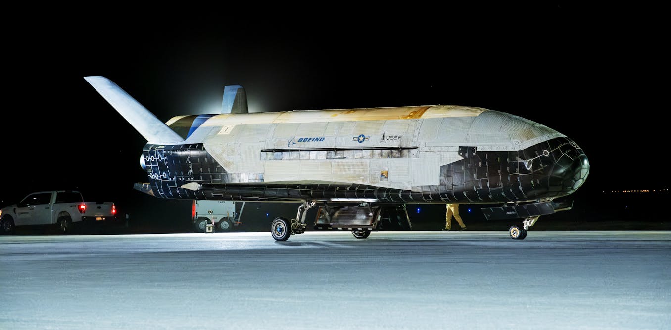
Quantum alternative to GPS navigation will be tested on US military spaceplane
The experimental sensor could be groundbreaking.

The Conversation (theconversation.com)
-
cross-posted from: https://programming.dev/post/35701350
Quantum alternative to GPS navigation will be tested on US military spaceplane
The experimental sensor could be groundbreaking.
The Conversation (theconversation.com)
This sounds pretty fancy.
Commercial aircraft get their location from multiple places including GPS, ground based facilities (VOR's), IRS, etc. IRS is what I'm used to calling it, but it's the same as INS, which is what this article is talking about.
It determines location by keeping track of rotation, acceleration, etc. It's often called "dead reckoning" because it just gives the best guess, and you don't know how accurate it is. There are multiple of these devices on each aircraft, and they compare their locations to the other sources and if one is drifting way further than the rest, it gets ignored. That's a very basic explanation because how it really works is way above my knowledge level.
It's very cool how these devices find their location, though. When you first boot the system up, it spends about 5 minutes measuring the rotation of the Earth. For this reason, you can't reset it when in motion. Based on what it feels it can determine your exact location on the surface of the earth.
-
This sounds pretty fancy.
Commercial aircraft get their location from multiple places including GPS, ground based facilities (VOR's), IRS, etc. IRS is what I'm used to calling it, but it's the same as INS, which is what this article is talking about.
It determines location by keeping track of rotation, acceleration, etc. It's often called "dead reckoning" because it just gives the best guess, and you don't know how accurate it is. There are multiple of these devices on each aircraft, and they compare their locations to the other sources and if one is drifting way further than the rest, it gets ignored. That's a very basic explanation because how it really works is way above my knowledge level.
It's very cool how these devices find their location, though. When you first boot the system up, it spends about 5 minutes measuring the rotation of the Earth. For this reason, you can't reset it when in motion. Based on what it feels it can determine your exact location on the surface of the earth.
To be clear, what you're describing is only true of INS. Other methods do not have these limitations, like GPS constantly receives the satellite signal to place your position.
-
cross-posted from: https://programming.dev/post/35701350
Quantum alternative to GPS navigation will be tested on US military spaceplane
The experimental sensor could be groundbreaking.
The Conversation (theconversation.com)
A beacon in the warp….
-
To be clear, what you're describing is only true of INS. Other methods do not have these limitations, like GPS constantly receives the satellite signal to place your position.
The article is about a highly accurate (orders of magnitude) INS system.
-
This sounds pretty fancy.
Commercial aircraft get their location from multiple places including GPS, ground based facilities (VOR's), IRS, etc. IRS is what I'm used to calling it, but it's the same as INS, which is what this article is talking about.
It determines location by keeping track of rotation, acceleration, etc. It's often called "dead reckoning" because it just gives the best guess, and you don't know how accurate it is. There are multiple of these devices on each aircraft, and they compare their locations to the other sources and if one is drifting way further than the rest, it gets ignored. That's a very basic explanation because how it really works is way above my knowledge level.
It's very cool how these devices find their location, though. When you first boot the system up, it spends about 5 minutes measuring the rotation of the Earth. For this reason, you can't reset it when in motion. Based on what it feels it can determine your exact location on the surface of the earth.
So it figures out where you are based on vibes?
-
cross-posted from: https://programming.dev/post/35701350
Quantum alternative to GPS navigation will be tested on US military spaceplane
The experimental sensor could be groundbreaking.
The Conversation (theconversation.com)
Does anyone know how much more accurate this is compared to other interferometer gyroscopes like fiber-optics?
-
This sounds pretty fancy.
Commercial aircraft get their location from multiple places including GPS, ground based facilities (VOR's), IRS, etc. IRS is what I'm used to calling it, but it's the same as INS, which is what this article is talking about.
It determines location by keeping track of rotation, acceleration, etc. It's often called "dead reckoning" because it just gives the best guess, and you don't know how accurate it is. There are multiple of these devices on each aircraft, and they compare their locations to the other sources and if one is drifting way further than the rest, it gets ignored. That's a very basic explanation because how it really works is way above my knowledge level.
It's very cool how these devices find their location, though. When you first boot the system up, it spends about 5 minutes measuring the rotation of the Earth. For this reason, you can't reset it when in motion. Based on what it feels it can determine your exact location on the surface of the earth.
Hmmm so in the future we will have AI best guessing planes locations?
Ye haw. -
This sounds pretty fancy.
Commercial aircraft get their location from multiple places including GPS, ground based facilities (VOR's), IRS, etc. IRS is what I'm used to calling it, but it's the same as INS, which is what this article is talking about.
It determines location by keeping track of rotation, acceleration, etc. It's often called "dead reckoning" because it just gives the best guess, and you don't know how accurate it is. There are multiple of these devices on each aircraft, and they compare their locations to the other sources and if one is drifting way further than the rest, it gets ignored. That's a very basic explanation because how it really works is way above my knowledge level.
It's very cool how these devices find their location, though. When you first boot the system up, it spends about 5 minutes measuring the rotation of the Earth. For this reason, you can't reset it when in motion. Based on what it feels it can determine your exact location on the surface of the earth.
When you first boot the system up, it spends about 5 minutes measuring the rotation of the Earth. For this reason, you can't reset it when in motion.
That's very interesting. I've heard a lot about IRS/INS, but I didn't know what it was doing during initialization.
It must be an extremely sensitive instrument if it can measure the rotation of the Earth. I'm wondering, does anyone in the cockpit have to sit still when it boots up? Because I can imagine walking around in the plane alone, or even just a powerful sneeze would already introduce some movement, not to talk about the ground handlers loading the cargo.
-
Does anyone know how much more accurate this is compared to other interferometer gyroscopes like fiber-optics?
https://www.nature.com/articles/s41467-025-58381-6
I'm not gonna do the math. But it seems those fiber once have a longer path relatively speaking, so higher latency
-
This sounds pretty fancy.
Commercial aircraft get their location from multiple places including GPS, ground based facilities (VOR's), IRS, etc. IRS is what I'm used to calling it, but it's the same as INS, which is what this article is talking about.
It determines location by keeping track of rotation, acceleration, etc. It's often called "dead reckoning" because it just gives the best guess, and you don't know how accurate it is. There are multiple of these devices on each aircraft, and they compare their locations to the other sources and if one is drifting way further than the rest, it gets ignored. That's a very basic explanation because how it really works is way above my knowledge level.
It's very cool how these devices find their location, though. When you first boot the system up, it spends about 5 minutes measuring the rotation of the Earth. For this reason, you can't reset it when in motion. Based on what it feels it can determine your exact location on the surface of the earth.
It's very cool how these devices find their location, though. When you first boot the system up, it spends about 5 minutes measuring the rotation of the Earth. For this reason, you can't reset it when in motion. Based on what it feels it can determine your exact location on the surface of the earth.
That gets you longitude but not latitude, right?
-
cross-posted from: https://programming.dev/post/35701350
Quantum alternative to GPS navigation will be tested on US military spaceplane
The experimental sensor could be groundbreaking.
The Conversation (theconversation.com)
So it thinks you're everywhere at once until you look out the window and observe your position?
-
cross-posted from: https://programming.dev/post/35701350
Quantum alternative to GPS navigation will be tested on US military spaceplane
The experimental sensor could be groundbreaking.
The Conversation (theconversation.com)
It's not really an alternative to GPS. It has no idea where on earth you are, it simply accurately tracks your motion through the world but it has no idea where that motion is occurring, you have to start off with a known starting point, then it tracks your motion to work out your current location. But it is only as accurate as the accuracy of the starting point, if that's off by 400 m then so will be the result.
It's basically a very good inertial navigation system, plus this isn't the first time it's been tested it's been tested on ships and planes before.
It's not going to replace GPS for commercial purposes because there's very few scenarios where you don't have a GPS up link. But it'll be useful is in situations where that's not possible like on submarines or yeah in space. It isn't like your car is ever going to use this though.
-
Hmmm so in the future we will have AI best guessing planes locations?
Ye haw.I doubt it'll ever be used on commercial aircraft, since they do have GPS and all the other things there isn't really any point adding a yet another system. Especially because it requires cooling, if it gets too warm it stops working, and buy too warm I mean the temperature of interplanetary space is too warm. Basically has to be absolute zero or bust.
-
cross-posted from: https://programming.dev/post/35701350
Quantum alternative to GPS navigation will be tested on US military spaceplane
The experimental sensor could be groundbreaking.
The Conversation (theconversation.com)
This would be a great idea for caving